Aerial Craft
Why Dubai Property Listings Sell Faster From the Air
Aerial photography is not a production luxury in Dubai real estate. It is the medium that shows a buyer where a property sits, what the views will be, and why the location commands the price it does.
- Aerial photography gives buyers the one thing ground-level marketing cannot: a true read of where the property sits, the surrounding context, and the views waiting at each floor.
- Dubai developers commission drone photography early, often before construction begins, to capture orbital imagery for 3D modelling and floor-level 360 panoramas that let buyers see their future view.
- SkyVision is a Dubai-based aerial photography and drone filming company operating across the UAE, guiding developers through permits, shooting windows and delivery from a single brief.
Aerial photography is the default language of Dubai property marketing, and it has been for good reason. No other medium can place a buyer inside the proposition: the tower rising at the edge of the creek, the golf course community spreading toward the Hajar foothills, the marina apartment whose entire value is the water view thirty floors below. Ground-level photography is honest about the unit. Aerial photography is honest about the address. In a market where the address is the product, that distinction moves listings.
What can aerial photography show that nothing else can?
The answer is context. A standard property photograph tells a buyer what is inside the unit. Aerial photography tells them everything outside it: the neighbouring developments, the distance to the waterfront, the park they will look down on, the road they will not hear because of the buffer behind the plot. These are the facts that justify a price per square foot, and they are invisible from the ground.
For off-plan developments, this is even more decisive. A buyer committing to a tower that does not yet exist needs something to trust. Drone photography of the plot, the surroundings and the skyline already in place gives them a real orientation. It is not a render. It is the actual site, in actual light, from the actual altitude the finished apartment will command. That credibility is worth more than any illustration.
How developers are using aerial beyond the hero shot
The cinematic aerial for the marketing brochure is only one application. Dubai developers and their agencies are increasingly commissioning drone flights for a second purpose that sits closer to technical infrastructure than to photography: orbital imagery for 3D reconstruction.
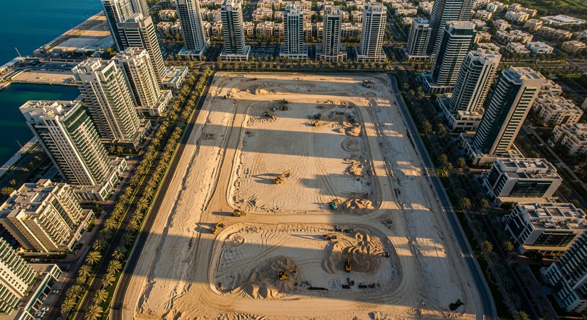
A precise orbital capture of a plot, flown at consistent altitude and interval, generates the photogrammetric data that feeds into AI modelling, CGI pipelines and full 3D site models. Developers use this before a single foundation is poured, as the base layer for visualisation teams to build the finished project upon. The same flight plan that produces a beautiful aerial for the campaign website also delivers the raw spatial data the digital team needs. Two outputs, one mobilisation.
Floor-level 360 panoramic views are a third application, and arguably the most powerful sales tool in an off-plan context. Captured at the specific floor heights of an unbuilt tower, using the surrounding skyline and horizon as reference, these panoramas let a prospective buyer step into the exact view from apartment 34B before the structure exists. Combined with a floor plan and a rendered interior, the uncertainty that slows off-plan decisions dissolves.
Who is commissioning this work, and when do they start?
The brief almost always originates with the developer's marketing department, not the agency. The agency executes, but the developer's team owns the content strategy because they own the sales timeline. In large-scale projects where the land is held by a separate entity, the marketing team also handles the NOC from the landowner before any flights can be scheduled. Understanding that chain early prevents delays later.
The timing is earlier than most outsiders expect. Aerial content is commissioned well before construction commences because the pipeline for off-plan marketing begins the moment the project is announced. Floor-level 360 views need to be captured while the surrounding skyline is still the primary reference. Orbital imagery for modelling is most useful when the plot is clear. The developer who waits until the hoarding goes up has already lost the most valuable shooting window.
Planning a campaign for an off-plan launch? SkyVision works with developer marketing teams from brief to delivery. Get a quote →
Which projects benefit most from aerial photography?
Not every project needs the same depth of aerial coverage, but certain typologies depend on it entirely.
Downtown and Marina skyscraper projects are the clearest case. The entire value proposition is vertical: the height, the view, the sense of being above the city. A ground-level photograph is structurally incapable of communicating that. Floor-level 360 panoramas and high-altitude aerials are not supplementary here. They are the primary sales material.
Large residential communities, particularly those built around golf courses, present a different challenge: scale. A golf-course development can stretch across several kilometres, and the only way to convey that landscape, the fairways, the water features, the relationship between the course and the residential clusters is from altitude. Aerial photography is not an enhancement for these projects. It is the only medium with a wide enough frame.
Large-plot villa communities and waterfront developments fall into the same logic. The land, the water proximity, the private access: these assets exist at a scale the camera can only read from above.
When should a developer schedule the shoot?
Light is the single biggest variable in aerial quality, and light in the UAE is a precise problem. The golden hours, the forty-five minutes around sunrise and sunset, produce the long shadows and warm tones that give aerial imagery its depth and drama. The same shot at midday, under a bleached vertical sun, is flat. The great aerials are planned around the calendar, not squeezed into the available slot.
Winter is the prime season. From October through March, the UAE sky is typically clear and deep blue, the air clean and the horizon sharp. Summer shoots are harder: the haze that builds through the warmer months can flatten the distance and reduce the contrast that makes a skyline read from altitude. That said, at the right time of day, with the right angle and the right lens treatment, compelling aerials are achievable year-round. The answer is not to avoid summer, it is to plan around its constraints.
When a developer needs both sunrise and sunset coverage across the same project, the same-day approach requires Ministry of Defense attendance for a shoot spanning more than a standard permitted window, typically a twelve-hour day. SkyVision coordinates that clearance directly. For projects covering multiple sites, the team can cover up to three locations in a single well-planned shoot day, consolidating the logistics and minimising disruption to the site programme.
What does a decade of Dubai aerial work look like in practice?
SkyVision has produced 360 panoramic and orbital work for multiple developer clients across the UAE. The portfolio spans off-plan tower launches, golf-course community campaigns and large residential masterplans. The work is available through the portfolio, and more specific project examples are available on request for developers evaluating a production partner.
The experience that matters most in this market is not purely technical. It is the knowledge of how the approval and permit process actually works for each location type, how to structure a shoot day to get both the creative and the data deliverables, and how to handle the specific variables of UAE light and airspace. That is the institutional knowledge that separates a smooth campaign production from a difficult one.
What a single aerial mobilisation delivers
Cinematic aerials
Hero footage and stills for campaign, digital and print.
Orbital photogrammetry
Spatial data for AI, CGI and 3D modelling pipelines.
Floor-level 360 panoramas
Exact future views at each apartment level, before construction.
Site mapping and context data
Plot boundaries, surrounding infrastructure and scale reference.
A single well-planned drone mobilisation can deliver four distinct content and data outputs for a developer's marketing and technical teams.
The developer who waits until the hoarding goes up has already lost the most valuable shooting window. Aerial content is commissioned before construction begins because the off-plan marketing pipeline starts the moment the project is announced.
SkyVision guides developer marketing teams through the full process: NOCs, permits, shooting windows, orbital imagery, 360 floor-level panoramas and the cinematic aerials that move property. Ten years of UAE aerial work, with a licensed crew and a single point of contact from brief to delivery.